The transformation of Tropical Storm Marie into a hurricane is raising concerns among residents as it heads towards Southern California during the Labor Day weekend. The Miami-based National Hurricane Center reported that the storm strengthened off the coast of southwest Mexico, progressing northward in the Pacific.
Impending Weather Impact
As Hurricane Marie intensifies, its swells are anticipated to reach the coast of southwestern Mexico and the Baja California peninsula over the coming days. Southern California beaches could start feeling the effects by the weekend. While some forecasting models suggest that the storm will approach the SoCal coastline, it is important to note that there is still uncertainty in its precise path. Most predictions indicate that it may remain offshore.
Should the hurricane move closer to the coast, residents may experience rain, strong winds, and heightened surf conditions over the holiday. The National Weather Service has already warned beachgoers of the likelihood of large waves and dangerous rip currents. There is also a moderate risk of coastal flooding, particularly affecting south-facing shorelines.
Understanding Spaghetti Models
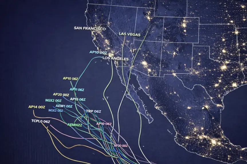
You might hear the term “spaghetti models” when tracking hurricanes, referring to the multiple forecasting lines that resemble a tangled plate of pasta. These diagrams, generated by some of the world’s fastest computers, illustrate possible storm trajectories derived from an array of calculations. A tighter cluster of lines signifies confidence in the projected path, while widespread lines indicate uncertainty.
There are various types of spaghetti models, including dynamical, statistical, and ensemble models. Dynamical models utilize supercomputers to solve complex equations, while statistical models base their forecasts on historical data. Ensemble models integrate the forecasts from these different types to provide a consensus view of the storm’s trajectory and intensity.
These models are operated by both governmental agencies and private companies globally. For instance, the U.S. Navy’s Fleet Numerical Meteorology and Oceanography Center runs the “Navy Global Environmental Model,” while the American GFS and European ECMWF models are well recognized in the meteorological community.
The best practice is to monitor these models regularly, as they are updated multiple times throughout the day. Observing consistency in their predictions is vital, as it helps identify trends regarding the storm’s direction and speed, allowing for better preparedness as the hurricane approaches.